Use Data to Make Operating Decisions
Use data to understand performance
on every field
on every field
Compare Maps Side‑by‑Side

Compare side‑by‑side yield, planting, field health maps and more, to monitor crop performance and better understand field variability.
Yield
Analysis

Easily analyse performance by hybrid, soil type, or field, so you can make the best decisions for next season. Export reports to print or share with your advisors.
Field Region
Analysis

Circle a region on your field map to generate a crop performance report. Use this information to determine how different agronomic practices impact yield.
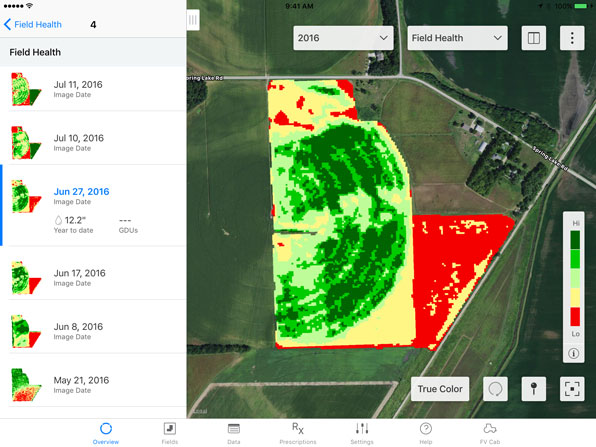
Stop problems before they start
Find out what’s happening beyond the end rows with imagery that can help you identify issues early and prioritise scouting. Climate FieldView™ uses a proprietary process to deliver consistent, high-quality satellite images so you can identify in-season challenges and take action to protect yield.
Prioritise scouting activities

Find out what’s happening beyond the end rows with imagery that can help you identify issues early and prioritise scouting. FieldView™ uses a proprietary process to deliver consistent, high-quality satellite images so you can identify in-season challenges and take action to protect yield.
IDENTIFY ISSUES EARLY

Use scouting maps to spot potential issues within a field and drop geo-located pins. Share with agronomic advisors to take action and save valuable time.
GET CLEAR FIELD INSIGHTS
Use true colour overlay to view a real-world image of your field. Compare it to vegetation and scouting maps to help identify clouds, ponding and other changes in your fields.